

Table of contents
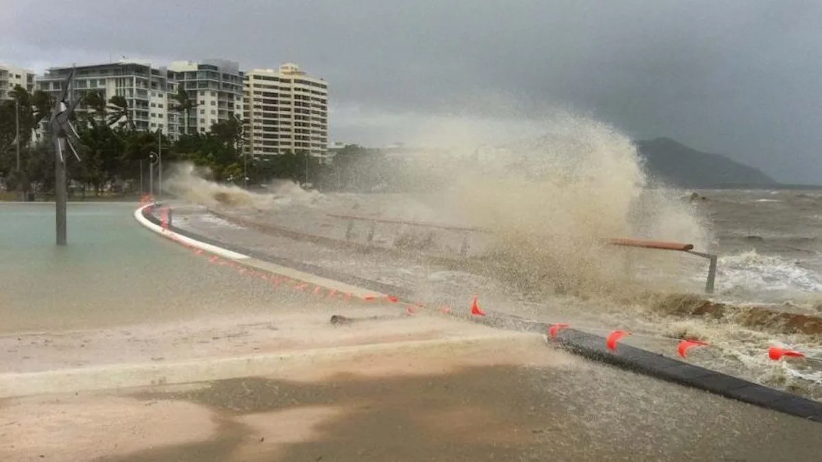
Cairns Flood Warning
Cairns flooding is a major issue for many people living in this tropical city in Far North Queensland. Much of Central Cairns is low-lying, making it vulnerable to flooding during the wet season. Now Climate Change is making things even worse.
Storm surges at times of high rainfall, especially during tropical cyclones, can create an emergency situation where lives are at risk.
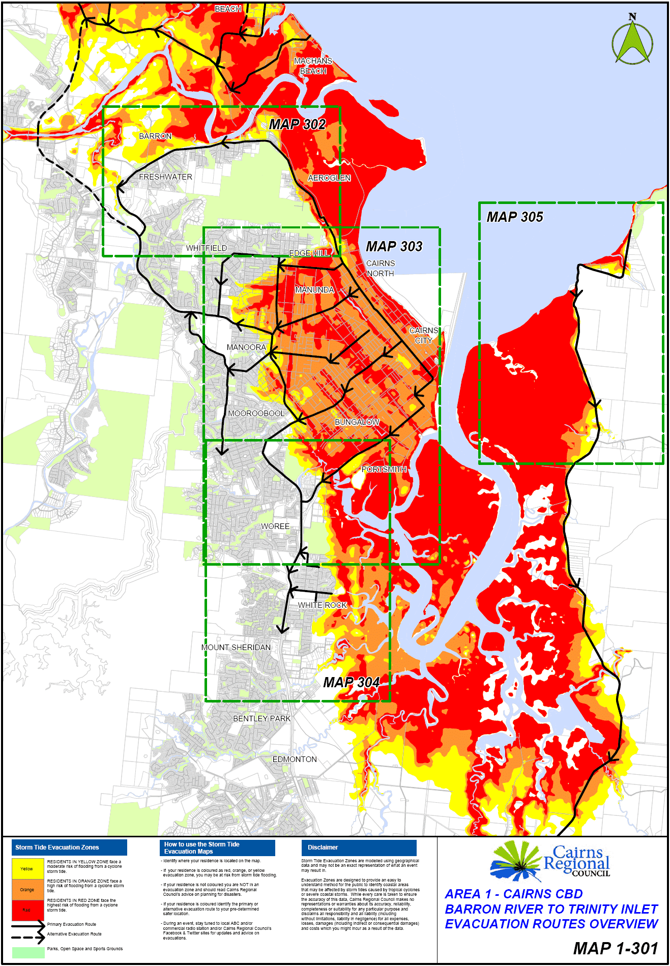
Cairns Flooding Map
Maps are readily available showing areas of Cairns that are ‘flood prone’ and need to be evacuated during natural disasters.
South Cairns has a fairly good degree of flood immunity. However, inner city suburbs and parts of the northern beaches may well be described as a disaster waiting to happen.
While the below map is more accurately described as a ‘storm surge map’ it accurately shows areas that are most vulnerable during a flood event.
Cairns Flood History
In the wet season, people are often aware of flood vulnerability in suburbs such as Portsmith, Bungalow, Cairns North and the Cairns CBD. However, they are not as aware of the possibility of flooding in other low-lying parts of Cairns.
The suburbs of Parramatta Park, Westcourt and Manunda are also highly vulnerable to sea-level rise and flooding, as this picture of Manunda flooding shows.
The northern beaches suburbs of Machans, Holloways and Yorkeys Knob are know to flood regularly, resulting in many residents being cut off from the Captain Cook Highway.
As a result of Cairns flooding history and rising sea-levels, some Cairns residents in low-lying areas will need to evacuate their homes more frequently. The best place to obtain advice on this is the Cairns Disaster Dashboard.

Cairns Disaster Dashboard
The Cairns Disaster Dashboard is the best way to stay in touch with Cairns flood events in real time.
Climate Change and Flooding
The vulnerability of Cairns to flooding is increasing. In addition to the regular torrential rains, a climate change double whammy is facing the city. Climate change is leading to both more intense flooding and rising sea levels.
In this environment, a significant storm surge during an intense tropical cyclone, could cause massive loss of life.
As a result of high annual rainfall, climate change and housing developments in low-lying areas, flooding is a real problem in Cairns. Housing in the Barron River delta, makes properties in that area particularly vulnerable to flooding.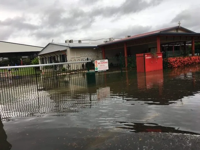
Cairns Floods 2024
Flooding in Cairns usually occurs in conjunction with the torrential rain that accompanies the tropical wet season.
Residents are encouraged to think about the coming summer and what preparations they can make. Should they be confronted with flooding later this year.
Barron River Delta
Council implemented a flood mitigation scheme in 2009. It was designed to help protect Lake Placid, Caravonica and Kamerunga residents from future flooding of the Barron River. It provides protection when the river breaks its banks with a 1- in-15 to 1-in-20 year flood.
A fact sheet for residents explained, “The lower Barron Delta starts to flood long before this, with access from the Captain Cook Highway disrupted by a 1-in-5 year flood event”.
More recently, there has been mapping to show the impacts of sea-level rise in the future. As a result, this sea level rise mapping indicates areas that will form part of the intertidal zone.
Clearly the impacts of king tides and climate change are already being felt. With ocean levels certain to rise further, the impacts will become even more dire in coming years.
The Barron Delta Sea Level Rise maps show a new intertidal zone. This includes previously flood immune land, which will become flood prone as a result of sea-level rise and more intense climate driven rainfall events.

Cairns flooding today
Thanks to technology these days we can see flooding in ‘real time’ in many locations.
Cairns Flood Cameras
There are links to a number of flood cameras on the Council website. This allows residents and disaster recovery staff to see what is happening from their desktop.
It is hoped these cameras will stop needless trips into dangerous areas by people wanting to inspect any flooding.
Cairns Flood History
If you are making an investment or other important decision concerning property in Cairns, we recommend you do a flood search and if needed engage a flood engineer.
Edmonton
Cairns southern suburbs are more protected than the city’s inner suburbs, but they can also experience inundation.
The flooding of parts of Edmonton in 1977 led to new drainage work by the local council. However, newer suburbs in West Edmonton and Mount Peter have even better levels of flood immunity. This should prevent any significant flooding in these locations.
Gordonvale
Cairns City Council flooding maps mention Q100. This is the best estimate of whether or not a property will flood (on average) more than once every 100 years.
Gordonvale does flood. However, few areas of Gordonvale are likely to flood more than once every hundred years. Cairns Regional Council has produced the Gordonvale flood map to show you if your property is vulnerable to flooding.
Cairns flooding airport
Cairns airport is in an area that is vulnerable to flooding. A King Tide in combination with a flood event is likely to flood the Airport.
Cairns Disaster Dashboard
People should remember that areas that are currently vulnerable to flooding and stormwater inundation, will only become more so as sea levels continue to rise as a result of climate change.
Climate Change and Future Flooding
Climate change on our warming planet is leading to rising sea-levels. This is largely a result of increasing meltwater from glaciers and ice sheets and thermal expansion of seawater as it warms. This is bad news for Cairns which has a densely inhabited coastal strip.
People buying property in either the red, orange or yellow zones (see above flood map) should seriously consider flooding and storm water inundation before completing a purchase. It may also be very difficult to obtain affordable insurance in these areas.
Useful/Interesting Cairns Links
- Cairns Facts
- Cairns Climate Change
- Cairns Creeks
- Cairns History
- Cairns Humidity
- Cairns Parks
- Cairns Post Office
- Gimuy
Comments
9 responses to “Cairns Flooding – Your Ultimate Guide 2024”
[…] Cairns Flooding […]
[…] Cairns Flooding […]
[…] Cairns Flooding […]
[…] Cairns Flooding […]
[…] Cairns Flooding […]
[…] Cairns Flooding […]
[…] Cairns Flooding […]
[…] Cairns Flooding […]
[…] King Tides and Climate Change have become survival issues for the world’s coastal cities. I live in the tropical city of Cairns. A Pacific rim city in the Far North of Australia. As a result, Cairns is a very low-lying city. Consequently, it is highly vulnerable to salt water inundation from sea-level rise. This is over and above former levels of Cairns flooding. […]